

Fixed Road weather stations (RWS) compared to fleet based mobile road measurements
Road weather is an umbrella term for classifying driving conditions on roads. It includes parameters that are directly connected to a road’s surface, such as road state (dry, moist, ice etc.), road friction (to determine slipperiness) and road temperature. However, atmospheric parameters and visibility for example, also include in this term.
Road weather sensing can be done in several ways. The traditional way of doing it is through fixed road weather stations. These stations are stationary and distributed over an area to give an overview of the current situation of all roads in that area. Typically they are situated at worst case scenario sections on main roads. The static road weather information stations can usually provide a handful of different data types from the road surface and from the atmosphere. However, the confidence of data can sometimes be an issue if the sensors are too far apart from each other, as measurements are often based on single low-fidelity sensors that don’t offer a possibility for cross reference with additional data points.
Another way of measuring road weather is by the help of mobile measurements, for example by using optical sensors. Whereas the static stations are stationary and hence provide data from the exact same position every time, the mobile road weather measurements move over the whole road network, capturing hyperlocal road weather data. With a well-designed optical sensor, and in combination with the car’s own CAN-bus data, mobile road weather measurements can capture almost as many data types as the stationary stations. This allows for a detailed real-time overview of the whole road network in road segments as short as 10 meters.
Road weather is hyperlocal
Road weather is extremely local and depends on a variety of factors. For example, the effect of winter weather on road conditions is influenced by factors such as dew point, temperature, cloudiness, road pavement type, road thermal capacity and traffic density, which are all very local in nature. This means that road slipperiness, caused by patches of black ice for example, can vary widely between sections of road as little as tens of meters apart.
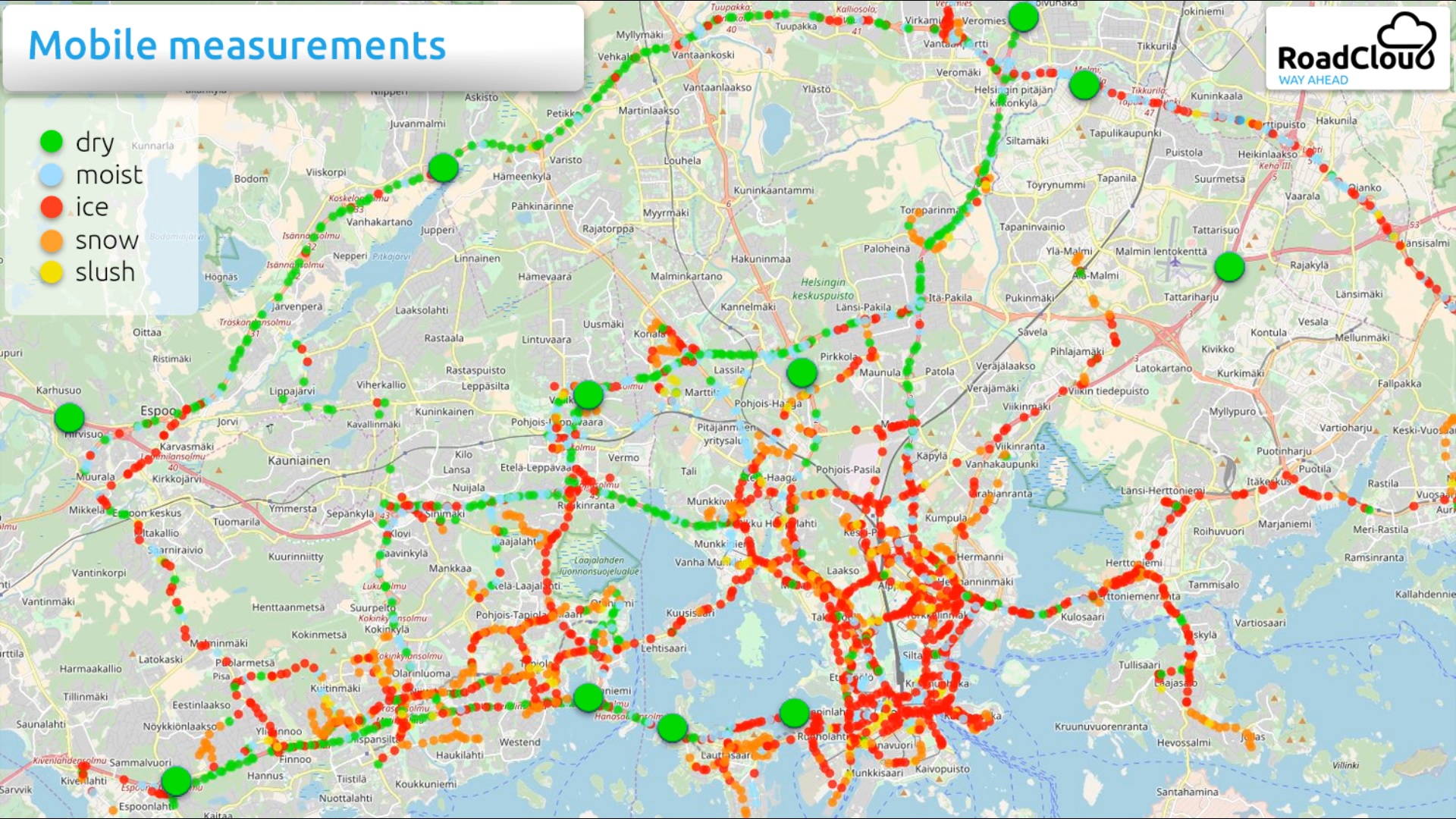
In the animation above we have compared the two types of measurements. Both measurements are taken at the same time of day from the Helsinki Metropolitan area, and both are measuring road state. The fixed road state measurements are the larger green circles. The more frequent, smaller circles mostly in red, are fleet based, high fidelity measurements taken by the RoadCloud fleet of commercial vehicles.
While the fixed weather stations show the road condition to be dry and driving conditions to be good, the RoadCloud hyperlocal mobile measurements give a completely different image of hazardous, icy driving conditions on many of the main roads. The weather stations were not necessarily showing the wrong results. However, many happened to be at road sections where the roads had been well maintained or were naturally in good condition.
As can be seen from the animation, a big difference between the two measurement types is hyperlocality, and hyperlocality matters when you are trying to understand highly local road weather. Yet, due to the static nature of the stations, the RWS spot-based measurements become too far apart, thus only showing a fraction of the road network’s actual condition. What the road condition is like in-between the weather stations remains unknown. If the Helsinki winter road maintenance staff would have based their decisions on RWS data only, no salting run would have started and the risk of accidents and disruptions to the traffic flow would have been significant.
Combining data sources
As has been discussed, mobile hyperlocal road weather data can provide insight into the road network beyond the fixed weather stations. Sometimes, it can also be misleading to judge road network conditions purely based on the static stations. As weather stations are typically located at worst case scenario road sections, it can in contrary to the animation above, also cause unnecessary maintenance call-outs and therefore costs.
However, a combination of data from fixed equipment and mobile hyperlocal road weather data can provide larger coverage for the provided data. Where vehicles have not been driving and measuring as often, static stations can provide supplemental data. The road state information for example is similar and can be interpreted the same way in both cases. Also, as an example, the ambient temperature information provided from the vehicles can be combined with the weather station information to create better understanding on local climates occurring on certain regions.
Are hyperlocal road weather measurements better than static road weather station measurements? Yes and no, both have their strengths and weaknesses. Some fixed stations can measure real-time visibility for example, something hyperlocal infra-red measurements can not. However, only by using comprehensive fleet based hyperlocal road weather data, such as RoadCloud’s, decisions on whether and where to apply road maintenance resources can be taken with a high level of confidence – enabling significant savings, reducing environmental impact and increasing safety for all road users.
As static road weather stations require maintenance, manual calibration and have high fixed costs, buying the data as a subscription service in a turnkey solution like RoadCloud’s means less hassle and can be a better option for some.
comprehensive mobile road data
Mobile road measurements based on manual spot-checks, which involve road staff physically checking road sections for slipperiness, have the same problem as static road information stations that they only cover a small section of the road network. So, how can comprehensive and accurate data be created for a city, motorway or service area?
The answer lies in applying sensors to fleets of commercial vehicles such as taxi’s, trucks and delivery vans that drive 24/7 on the entire road network. By equipping highly utilized vehicles with a sensor package, a very small part of overall traffic (below one permille) will generate sufficient coverage to provide continuously updated data.
The granularity of the measurements means that resulting data can be provided in road sections as short as 10 meters for the entire road network. By accessing these high-fidelity data points, covering millions of kilometres of your road network yearly, it allows you to react in real-time to put in maintenance staff, but it also let’s you analyse the actual condition of your road network on a much deeper level. What road sections are repeatedly slippery? What road sections are most prone to causing aquaplaning risks? Or what parts of the road network that need more accurate road surface checks to prevent serious pavement deterioration.
For further reading about the topic of hyperlocal and real-time road weather measurements, check out our free white paper: A Data-Driven Road to Safer, Greener and More Efficient Winter Road Maintenance.